Arkansas Society of Professional Surveyors
The Arkansas Society of Professional Surveyors (ASPS) is a non-profit association dedicated to serving the public interest and advancing the profession of surveying.
If you have renewed your membership, but the member rate is not showing, please log out then log back in.

Total Credits: 15 including 15 Professional Development Hours, 2 Minimum Standards Credit
| Practical Geodesy for Practical Surveyors (17.4 MB) | Available after Purchase | ||
| New Datums, New Coordinates, New Heights (8.6 MB) | Available after Purchase | ||
| Arkansas Minimum Standards Review (3.3 MB) | Available after Purchase | ||
| Introduction to Riparian Boundaries (2.7 MB) | Available after Purchase | ||
| General Membership Meeting (49.2 KB) | Available after Purchase | ||

Dave Doyle has been engaged in geodetic surveying since his enlistment in the U.S. Army in 1967. In 1972 he joined the National Geodetic Survey and held the position of chief geodetic surveyor for twelve years prior to his retirement in January 2013. He was responsible for the development, technical design and management of plans and programs that enhanced the United States National Spatial Reference System. During his career his experiences included all phases of geodetic triangulation, astronomic positioning, leveling, GPS data collection, data analysis, datum transformations, network adjustments, data publication and outreach in the form of seminars, workshops and webinars. His efforts also included extensive activities to direct and coordinate the modernization of national geodetic reference frames in countries in Africa, Central, Caribbean and South America, Eastern Europe and the Pacific.
Mr. Doyle is a Past President and Fellow member of the American Association for Geodetic Surveying, has served on the U.S. delegation to the International Federation of Surveyors and is an active member of the District of Columbia, Maryland and Virginia professional surveyors associations. He is the recipient of numerous service awards from federal, state and national surveying agencies and organizations including the AAGS Joseph Dracup Achievement Award (2018) and the Maryland Surveyor of the Year (2008).

Eric Benson is the Geodetic Surveys Coordinator for ARDOT. Eric has a background in Land Surveying and has been at the department for 11 years. Eric graduated from UACCM with an associate’s degree in surveying and has his SI license. Eric is the proud father of 2 kids and enjoys being active in the community.

Sharon graduated from the University of Central Arkansas’ Geography program in 1999, and for the past 26 years, she has worked in the GIS and Mapping Section at ARDOT where she currently serves as Section Head. Sharon and her team provide the Department and the public with city, county, and statewide maps, spatial databases such as the all public roads dataset, and methodologies and applications to collect, view, and analyze spatial information. Her favorite aspect of the job is cartography, and she’s excited to talk to the surveying community about the past, present, and future of maps and spatial data at ARDOT.

Daniel is a lifelong native of central Arkansas and is passionate about all things surveying. He has been involved with land surveying for over 13 years and has been a licensed surveyor since 2016. As State Surveyor of Arkansas, Daniel is responsible for leading Arkansas’s Division of Land Surveys. This role includes maintaining Arkansas’s Public Land Survey System, prescribing statewide surveying rules, and managing an archive of over 200,000 survey plats. Daniel works closely with the surveying industry, Arkansas GIS Office, Board of Licensure for Professional Engineers and Professional Surveyors, ArDOT, National Geodetic Survey, the Arkansas Society of Professional Surveyors, and the citizens of Arkansas.
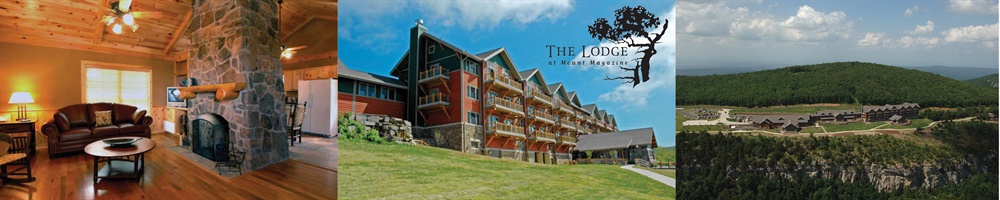
Call 479-963-5151 to make reservations.
View the resort at www.mountmagazinestatepark.com
Group room rates start at $166.80. Be sure to reference our group ID#955022 or name (ASPS) when making your reservation.
If you prefer to register by mail, use the appropriate form below to send in with your payment.
Registration Form for MEMBERS
Registration Form for NON-MEMBERS (call our office at 501-321-0958 or register online)
Q1: What is included with my registration?
A1: It depends on the registration type. See below:
What is included with LICENSED MEMBER AND NON-MEMBER registration?
- Access to all sessions
- PDH certificate which can be claimed online at the end of the conference
- Access to online portal with any speaker reference materials
- One lunch meal for both Thursday and Friday (Dinner is on your own)
What is included with UNLICENSED PERSONNEL, STUDENT, AND ASSOCIATE registration?
- Access to all sessions
- Access to online portal with any speaker reference materials
- One lunch meal for both Thursday and Friday (Dinner is on your own)
Q2: What is the cancellation policy?
A2: Registration can be canceled up through Monday, October 20. After that date, and through October 24, a refund can be requested minus a $75 cancellation fee. After October 27, no refunds can be granted.
Q3: Will the sessions be presented virtually as well?
A3: No.
These presentations detail the historical and contemporary developments of the horizontal and vertical geodetic datums of the United States including: the North American Datum, North American Datum of 1927 (NAD 27), North American Datum of 1983 (NAD 83), the National Geodetic Vertical Datum of 1929 (NGVD29) and the North American Vertical Datum of 1988 (NAVD 88) as well as the accepted global system the International Terrestrial Reference Frame (ITRF).
The sessions will highlight significant changes in measurement and positioning technologies and their impact on the development of reference ellipsoids, geoid models and contemporary high accuracy reference frame enhancements. These presentations are designed to provide a foundation for further discussions that will focus on the rationale for national reference system changes by the National Geodetic Survey now scheduled for 2026.
In 2026, the National Geodetic Survey (NGS) plans to deliver new and improved horizontal and vertical geodetic datums for the country. These enhancements will embrace significant advancements in earth orientation measurement systems and reflect high levels of interagency collaboration to provide more accurate and contemporary positional and height information detailing the foundation of the National Spatial Reference System. The community of professional surveyors will have the opportunity to provide a significant leadership role in the adoption of these new systems to a vast array of other disciplines in the private and public sectors at the local, state, and national levels. It will be important for these professionals to understand the rationale for this effort and the magnitude of changes expected in geodetic heights and positions resulting from significant changes in the State Plane Coordinate System.
Building on the momentum from our spring forum, the ASPS Fall Conference will host an "Update on Surveying Licensure Reform." This interactive forum will provide a progress report on our efforts to reform Arkansas's surveying licensure process, following the membership's unanimous motion to pursue legislative changes to A.C.A. § 17-48-203. Key topics include exploring flexible pathways for counting pre-education or concurrent experience toward licensure, identifying best practices from other states, and addressing potential impacts on professional standards and workforce sustainability.
Moderated by ASPS President, Aaron Rasburry, who will also serve as a panelist, the panel will include ASPS Board members Lanny Beavers and Jeremy Lawson. Attendees will hear updates on the ASPS Board's initial proposals, including discussions on the number of allowable experience years and whether experience during education should qualify. This is a prime opportunity for members to offer feedback, share concerns, and help refine our legislative strategy ahead of the 2027 legislative session.
This session will discuss the development of the ARDOT CORS Network and how the network will make the transition to the new datums developed by NGS.
The GIS and Mapping Section of ARDOT produces city maps, county maps, the state highway map (tourist map), and many other maps published for public use. This session will provide an overview of the GIS and Mapping Section as well as discuss the history of mapping at ARDOT.
This course provides surveyors with a comprehensive overview of the Arkansas Standards of Practice for Property Boundary Surveys and Plats. Drawing from statutory and regulatory guidance, the course reviews key requirements for research, monumentation, field procedures, accuracy standards, plat preparation, and distribution.
Topics include area classification and corresponding positional tolerances, survey types (urban, suburban, rural, remote), BLM guidance for section corner restoration, monument standards, and mandatory plat content. Attendees will also examine legal definitions, acreage reporting, and filing obligations with the State Surveyor’s office. Emphasis is placed on real-world application and compliance with Arkansas statutes, making this course essential for anyone involved in land surveying across the state.
This seminar introduces surveyors to the fundamentals of Arkansas riparian and littoral boundary law, based on Dr. Richard L. Elgin’s Riparian Boundaries for Arkansas. Key topics include accretion, erosion, avulsion, reliction, and the legal implications of navigability. The course also examines boundary markers such as the OHWL, thread of the stream, and thalweg, and explores how meander lines, island formation, and artificial changes affect title. Emphasis is placed on practical field application, legal context, and Arkansas-specific doctrines with broader regional relevance.